In Flight USA Article Categories
In Flight USA Articles
Flying Into Writing: Last Photo Mission Of The Year
By Eric McCarthy
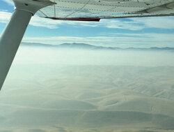
 Persistant haze over the central valley. (Eric McCarthy)The last day of the year started as a mostly clear day, a little haze visible on the horizon, but a good 20-25 miles visibility. The marine layer, so prevalent along the southern California coast at this time of year, had receded. My son, Mike, and I departed Palomar (KCRQ) around 9:30am headed north to our refueling stop at Los Banos (KLSN). Depending on the winds aloft, the flight usually takes two and a half to three hours – naturally, we got the three hour flight.
Passing through LAX’s Class Bravo via the Coliseum Route at 8,500-feet, I usually continue on course to Van Nuys VOR (VNY) and then, for no particularly good reason, my northbound route of flight usually takes us to Fillmore VOR (FIM), then northwest along V107 to Avenal VOR (AVE) and beyond. This time, however, the massive Thomas Fire, which had been burning for almost a month at this point, eventually consuming more than 280,000 acres, and its equally massive TFR necessitated a change of plans: we’d fly north to Gorman VOR (GMN), then to Avenal. Not a big change, but a change nonetheless.
Crossing into the Central Valley at Grapevine, it became clear – that it wasn’t anymore; as far as the eye could see, the valley was filled with low-level haze. I think this may be known as Tule Fog, but it really wasn’t ground-bound fog – just a thick haze that filled the valley. You could see the ground if you looked straight down, but slant-range visibility was very limited. The haze topped out at about 2,500-feet, so we weren’t concerned cruising along at 8,500-feet. But that would change soon enough…
The Los Banos AWOS was reporting VFR conditions, but as we descended approaching the Panoche VOR (PXN), still in the clear, I could see that this wasn’t going to be an easy VFR approach. The haze hadn’t lessened; in fact it may have thickened! I was talking to NorCal at the time and requested a practice GPS 32 approach, just to make sure I would be pointed in the right direction. The approach calls for a turn to the north at 3,600-feet from Panoche, so we were still above the soup until we reached the initial fix at ILESE; from there we began our descent into the haze. Forward visibility dropped considerably, although, as before, we could look straight down and see the ground beneath. The airport made its appearance right where it was supposed to be, visible right at the three mile VFR limit, and we made an uneventful landing.
Flying Into Writing: Some Things Have Changed Over the Years…
By Eric McCarthy
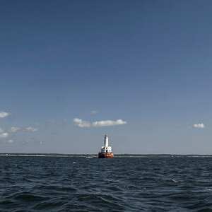
 Buzzard’s Bay (Courtesy Ben Nugent/Martha’s Vineyard Chamber of Commerce)Ahh…it seems like only yesterday! My long cross-country as a student pilot…
I was speaking with one of my CAP squadron-mates the other day and asked how close he was to finishing his Private Pilot license. He said he had just a couple of items left, including his solo long cross-country. Since he was training at a Part 141 flight school, his cross-country merely had to cover at least 100nm. As I look at the FARs today, it appears that the requirements may have been relaxed from when I did my long cross-country years ago. As I recall, my flight had to have three legs of at least 100nm each.
At the time I was training at Turners Falls (0B5), a remote, picturesque airport located at a sharp bend in the Connecticut River in north central Massachusetts. The airport has a 3,200-foot runway that sits on a plateau about 50 feet above the river, which to me as a young aviator provided an exhilarating view when approaching runway 16 over the river.
I had planned my flight under the supervision of my instructor and just needed the weather and aircraft availability to cooperate. That day arrived in July, 1980. I had graduated from UMass that May, and had been making the 100 mile trek from my home in eastern Massachusetts to complete my training at 0B5 since then, but that was getting tedious – especially since I lived under the traffic pattern of Norwood Memorial Airport (KOWD). This would end up being my last flight from Turners Falls.
My flight would take me from Turners Falls to Portland International (KPWM); from there to Martha’s Vineyard (KMVY); and then back to Turners Falls; total distance: about 360nm. It would take me almost five hours’ flight time to complete in the club’s Cessna 152, N49394.
Flying Into Writing: It’s All About Your Perspective
By Eric McCarthy
 Corrizo Plain and hills in bloom as far as we could see. (Eric McCarthy)Cruising along serenely with my friend and fellow CAP squadron-member, Derek, we passed over the LA Coliseum at 8,500 feet en route to Van Nuys VOR (VNY). We were flying up the Central Valley for one of my photo missions in my friend, Rich’s, Cessna. It was a beautiful day with few clouds and unlimited visibility. We had a bit of a headwind as we traversed the mountains on V107 north of the Fillmore VOR (FIM), and had been anticipating some turbulence, but it never materialized, and we were able stay at 8,500 feet for the crossing.
There’s some pretty inhospitable territory in those mountains, with not many options for an emergency landing. Subconsciously, I began to “cheat,” adding a little “insurance altitude” by climbing to 9,000 feet; Derek called ATC to request a block of airspace between 8,500 feet and 10,000 feet. Other than the airliners passing way overhead and a couple of business jets on their way to Van Nuys (KVNY), there was no other traffic, so our request was immediately granted.
Entering the Central Valley south of Taft, the scenery changes dramatically – from rugged, forested mountains to rolling hills and flat agricultural land that stretches to the horizon. Much of the land below us throughout this area has been scarred by oil production, a pock-marked labyrinth of drilling sites, empty pads, and storage facilities, but to our left is a spectacular view of the Southern Coastal Range and Carrizo Plain in full bloom. The recent winter rains brought out the vibrant greens and brilliant yellows of the wildflowers covering the hills and valleys as far as the eye could see! These hills and valleys are usually a monochromatic tan suede color, so to see them in bloom like this was quite a treat!
Pressurized Skyhawk?
By Eric McCarthy
There we were, climbing out of Paso Robles (KPRB) in my friend’s Cessna 172, joining our course line to the Fellows VOR (FLW). We had completed our photo mission in the Central Valley, refueled the plane at Los Banos (KLSN) and ourselves at Paso, and now it was time to head home. We contacted Oakland Center to request VFR Flight Following for the 233nm, two-hour flight back to Palomar (KCRQ).
Our course would take us over the mountain range just north of Santa Barbara on Victor 485, to OHIGH intersection where we turn east to enter the LA basin. On a calm, clear day, you can get over the coastal range safely at about 7,500’ although I usually prefer to carry extra altitude and make the crossing at 9,500’, both to escape the orographic turbulence and to provide greater glide range in case anything goes awry–those mountains are pretty rugged and unforgiving.
Passing Fellows it became clear that 9,500’ was not going to be enough to get over the cloud layer that had developed along the coast and the mountains ahead. They began as widely scattered fair-weather cotton balls and progressed to thick cumulous billows as we got closer to the mountains. Ok, up we go! Rich broke out the oxygen cannulas as we climbed through 10,000’.
Flying Into Writing
By Eric McCarthy
Hello world! Welcome to my first column in In Flight USA magazine. I’m excited to share my experiences of the past, present, and future with you. I look forward to bringing you along as I explore my new home in the southwest, present “lessons learned,” and advance my aviation knowledge and skills. This should be fun!
Allow me to provide a little background: I earned my Private Pilot License in 1980, fresh out of college – I’m a long-time flyer, if not a high-timer. My father, an MIT-trained aeronautical engineer, had introduced me to flying at a young age. He earned his PPL and took me up in a rented Cessna 172 when I was in third or fourth grade. It was a short hop from Hanscom Field (KBED), just west of Boston, to Norwood Airport (KOWD), just south of Boston, but that was all it took. To see the world from a few thousand feet was just magical to a young boy! I was hooked! I couldn’t get enough of it! I loved the maps and figuring out the “secret” codes they contained about the airports, terrain, and obstacles. I’d read and cut out pictures of airplanes from his Aviation Week and Flying magazines, often before he’d had a chance to see them – drove him crazy!