In Flight USA Article Categories
In Flight USA Articles
Flying Into Writing: Last Photo Mission Of The Year
By Eric McCarthy
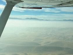
 Persistant haze over the central valley. (Eric McCarthy)The last day of the year started as a mostly clear day, a little haze visible on the horizon, but a good 20-25 miles visibility. The marine layer, so prevalent along the southern California coast at this time of year, had receded. My son, Mike, and I departed Palomar (KCRQ) around 9:30am headed north to our refueling stop at Los Banos (KLSN). Depending on the winds aloft, the flight usually takes two and a half to three hours – naturally, we got the three hour flight.
Passing through LAX’s Class Bravo via the Coliseum Route at 8,500-feet, I usually continue on course to Van Nuys VOR (VNY) and then, for no particularly good reason, my northbound route of flight usually takes us to Fillmore VOR (FIM), then northwest along V107 to Avenal VOR (AVE) and beyond. This time, however, the massive Thomas Fire, which had been burning for almost a month at this point, eventually consuming more than 280,000 acres, and its equally massive TFR necessitated a change of plans: we’d fly north to Gorman VOR (GMN), then to Avenal. Not a big change, but a change nonetheless.
Crossing into the Central Valley at Grapevine, it became clear – that it wasn’t anymore; as far as the eye could see, the valley was filled with low-level haze. I think this may be known as Tule Fog, but it really wasn’t ground-bound fog – just a thick haze that filled the valley. You could see the ground if you looked straight down, but slant-range visibility was very limited. The haze topped out at about 2,500-feet, so we weren’t concerned cruising along at 8,500-feet. But that would change soon enough…
The Los Banos AWOS was reporting VFR conditions, but as we descended approaching the Panoche VOR (PXN), still in the clear, I could see that this wasn’t going to be an easy VFR approach. The haze hadn’t lessened; in fact it may have thickened! I was talking to NorCal at the time and requested a practice GPS 32 approach, just to make sure I would be pointed in the right direction. The approach calls for a turn to the north at 3,600-feet from Panoche, so we were still above the soup until we reached the initial fix at ILESE; from there we began our descent into the haze. Forward visibility dropped considerably, although, as before, we could look straight down and see the ground beneath. The airport made its appearance right where it was supposed to be, visible right at the three mile VFR limit, and we made an uneventful landing.